teaching_robots_navigation
SLAM and other algorithms
-
need a map and need to know where we are
-
without a map you have a chicken and egg problem
-
without a map you do not know where you are
-
if you do not where you are, you cannot construct a map
-
the solution is to simultaneously create a map and localize
-
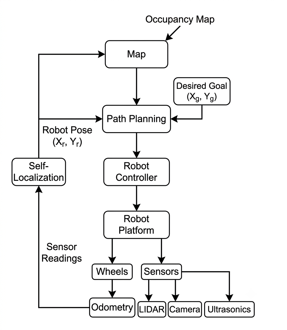
use odometry
-
map
-
self-localisation
-
path planning
Odometry based SLAM
- what is odometry?
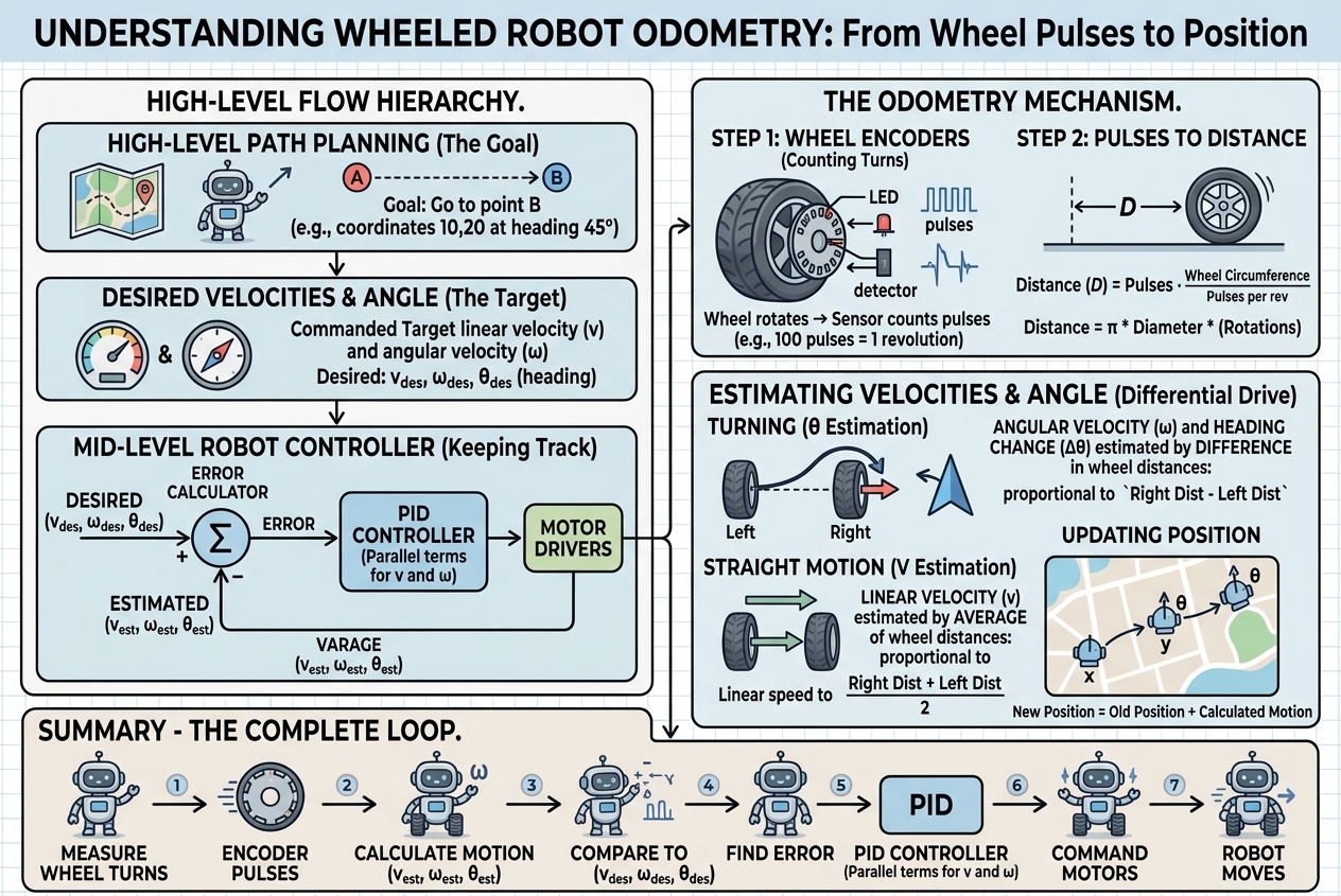
Odometry is the use of motion sensor data (such as wheel encoders or IMUs) to estimate how an object’s position and orientation change over time, usually relative to a starting point
-
This involves the use of odometry to self localise and to build maps.
-
This is due to using the diameter D which is in physical units (e.gcm, meters etc) to get the distance travelled in the x, y coordinates of the world.
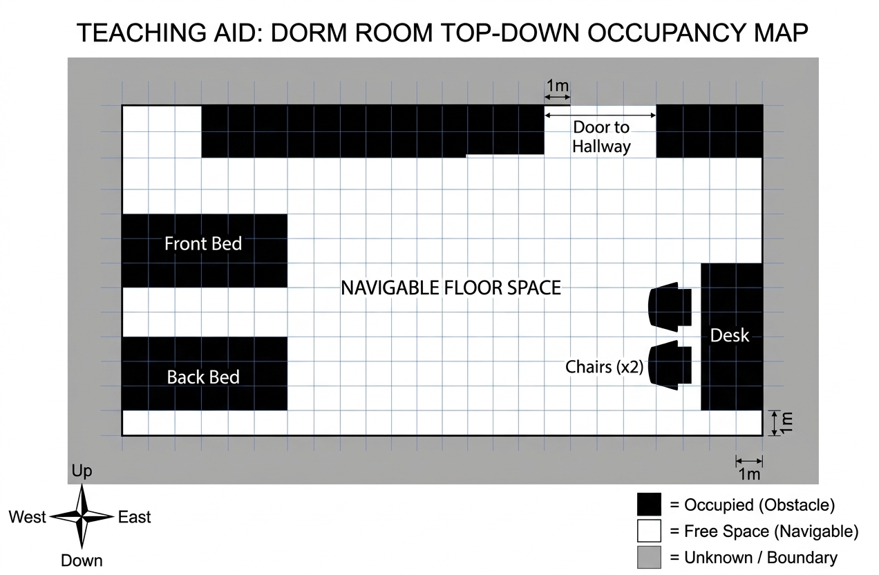
Occupancy map
-
exploration of environment
-
position estimation using robot pose
-
sensor values interpret (LIDAR, sonar, vision, etc.)
-
integration of sensor values into map (based on distance from robot and pose estimation of robot)
-
robot starts from origin (charging point)
-
fires off laser and use trigonometry to figure out location of object (based on returns from laser)
-
reactive explorer
-
what happens to table? robot can go underneath. the choice is with you
-
divide into grids
-
binary (occupied/not occupied) within each cell
SLAM
-
Simultaneous Localization and Mapping (SLAM)
-
which came first: the egg or the chicken?
-
robot wants to go from point A to point B: but it does not know what the world looks like?
-
so it needs a map
-
but what if there is no map?
-
try to build a map when there is no map!
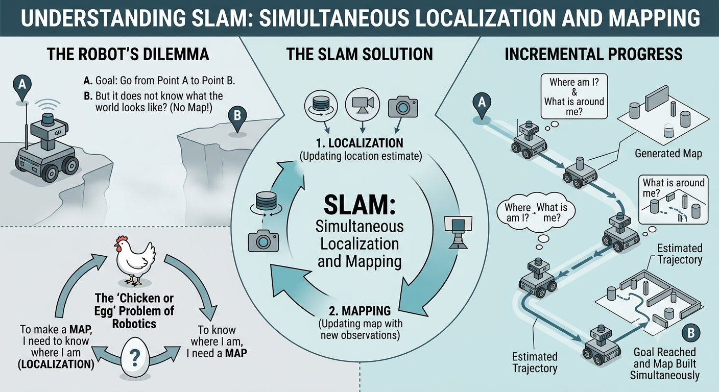
- simultaneously map and simultaneously localize
Workflow
-
wheels -> odometry
-
if humanoid robot then joints
-
IMU: inertial measurement unit
-
odometry: key to robotics platforms
-
odometry assumption: robot should know where is origin (0,0,0)
-
for vacuum cleaner, it is charging point. can self localize from there
-
all sensor input goes to build occupancy map
-
use the equations to build an occupancy grid for the environment
-
more detailed notes here
-
global coordinate transformation equations
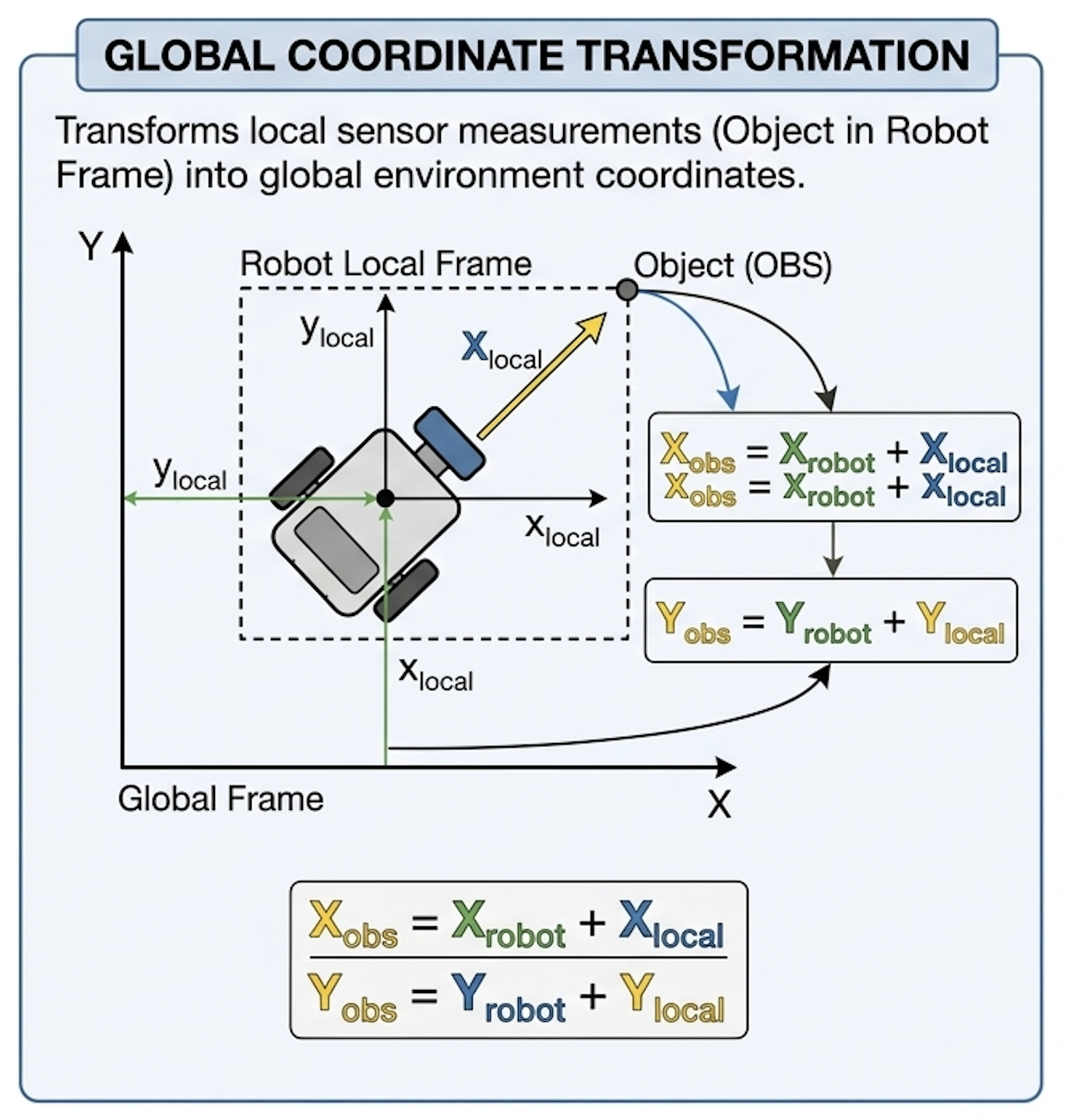
- Typical SLAM loop
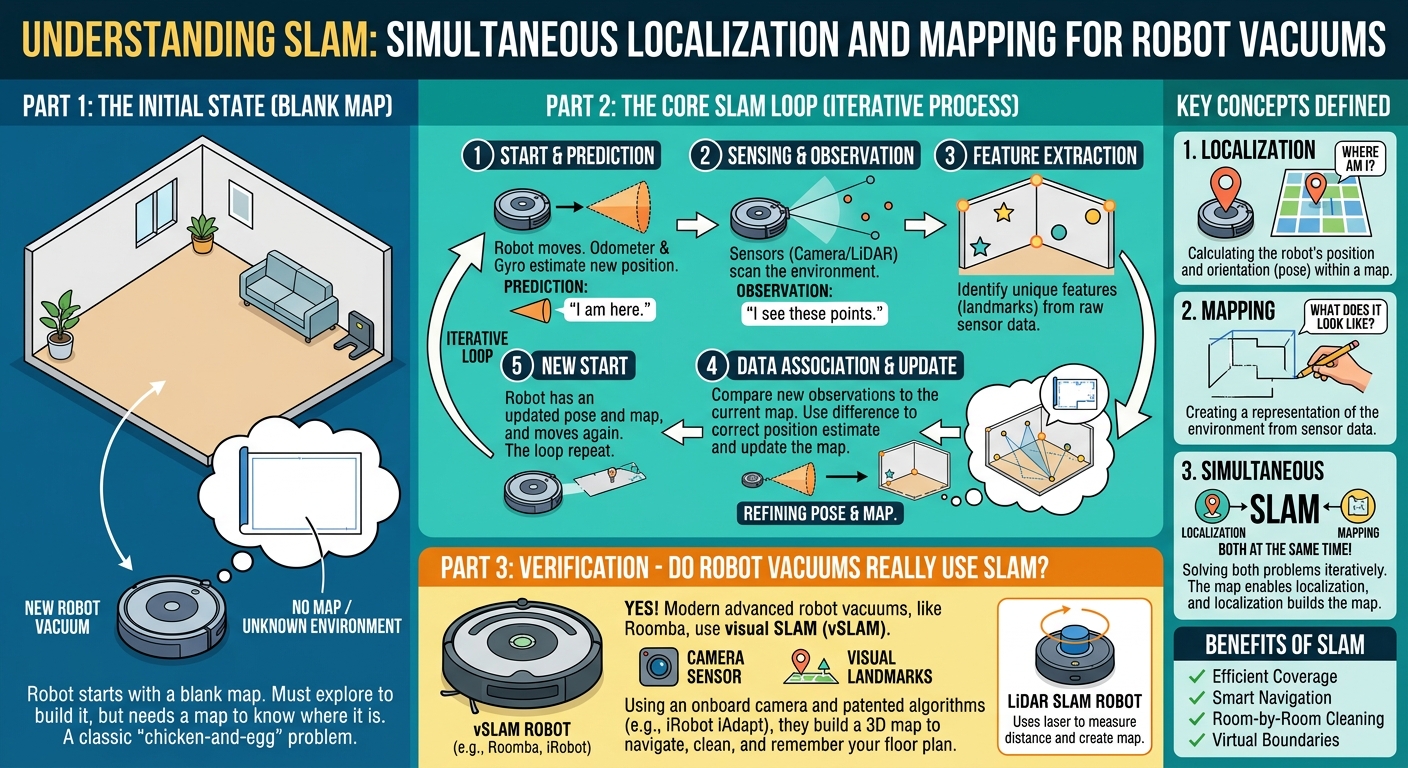
- Predict the new pose from odometry (wheel encoders, IMU).
- Sense the environment with range sensors or a camera.
- Match the new scan against the current map to correct the pose.
- Update the map using the corrected pose (Section 3).
- Close loops: when the robot returns to a known place, correct accumulated drift across the whole trajectory.
- 🤔 ❓ how does a new robot vacuum cleaner navigate in a new room?
-
🤔 ❓ what is the problem?
-
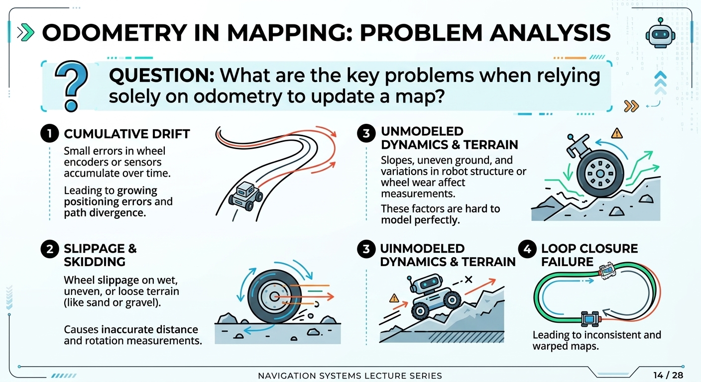
relying too much on odomtery
-
can be slippage, etc
-
self localizing due to odometry can be problematic
-
every rotation adds up
-
map can be erroneous
-
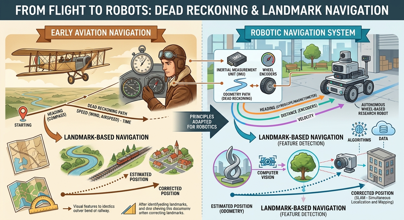
dead reckoning (early days of flight)
-
v = d/thas a clock, how much distance travelled in a time period -
look for a particular direction on compass
-
and then look for a landmark
-
LondonEye is a landmark for flights
-
correct for drift
-
greater the distance between landmarks, the greater the drift
-
can miss landmark
-
static
-
vacuum robot : not move chairs
-
distinct landmarks and unique locations (QR codes, colours)
-
database of landmarks with locations
-
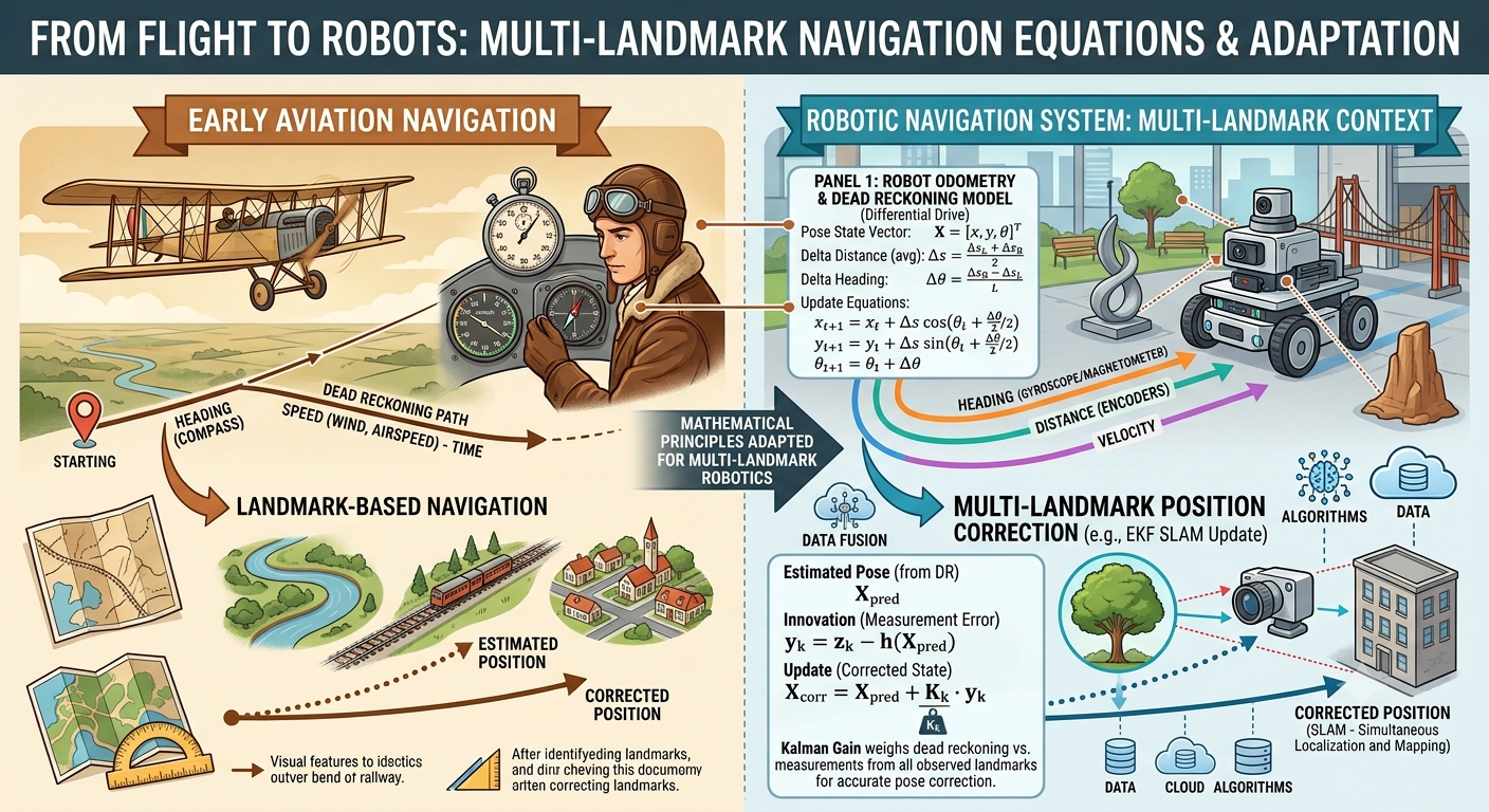
weights landmark more than odometry and then update location
-
equations
-
🤔 ❓ imagine you have been asked to design a vacuum robot that will work in an office with glass doors. what problems will you face?
-
problem with laser: can shine through, narrow beam
-
glass may refract
-
with glass room, use ultrasound
-
design issues in industry: vacuum robot in glass offices, but office may have glass
-
combinations of sensors
-
landmarks may look similar
-
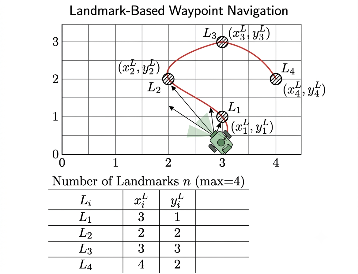
building a robotic tour guide (in Legoland)
-
landmarks locations known and do not move
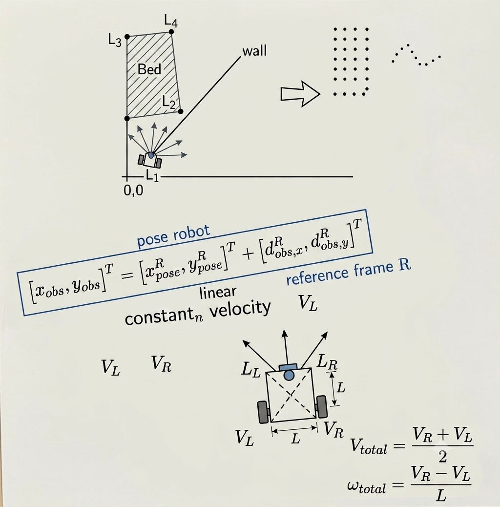
- waypoint navigation using landmarks
Rvis
- Rvis will show lasers as dots
Particle Filters
-
particles generated
-
Initialization: The robot starts with no prior knowledge, so it scatters potential positions (particles) uniformly across the map.
-
Prediction: As the robot moves, it uses its motion model, combined with added random noise to account for uncertainty, to propagate all particles.
-
Correction: The robot takes sensor measurements (e.g., via Lidar). Each particle predicts what it would measure. Particles whose predictions closely match the actual measurements are given a high “importance weight.”
-
Resampling: A new set of particles is formed, favouring those with high weights. This effectively eliminates unlikely hypotheses and duplicates the most plausible ones
-
Convergence: The process repeats, and over multiple cycles, the cloud of particles converges on the robot’s actual pose.
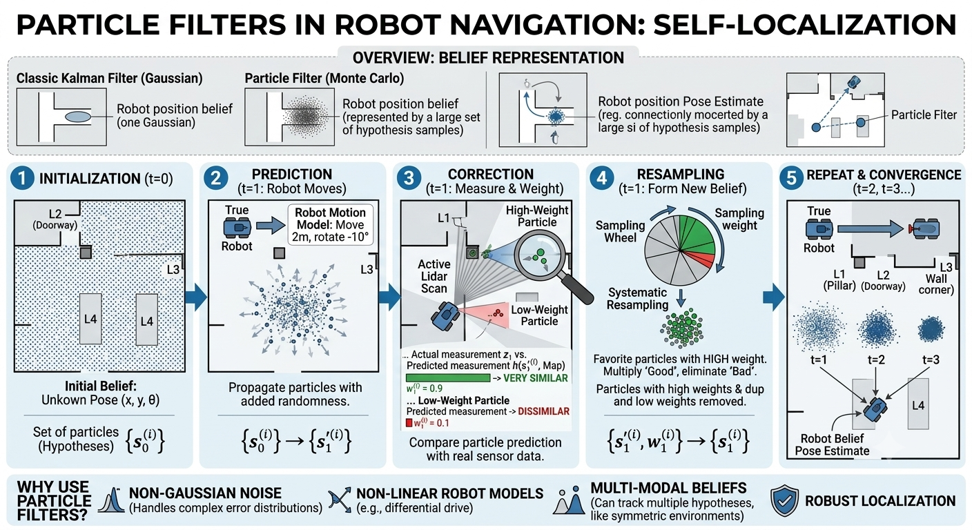
- constantly resample and refine positions
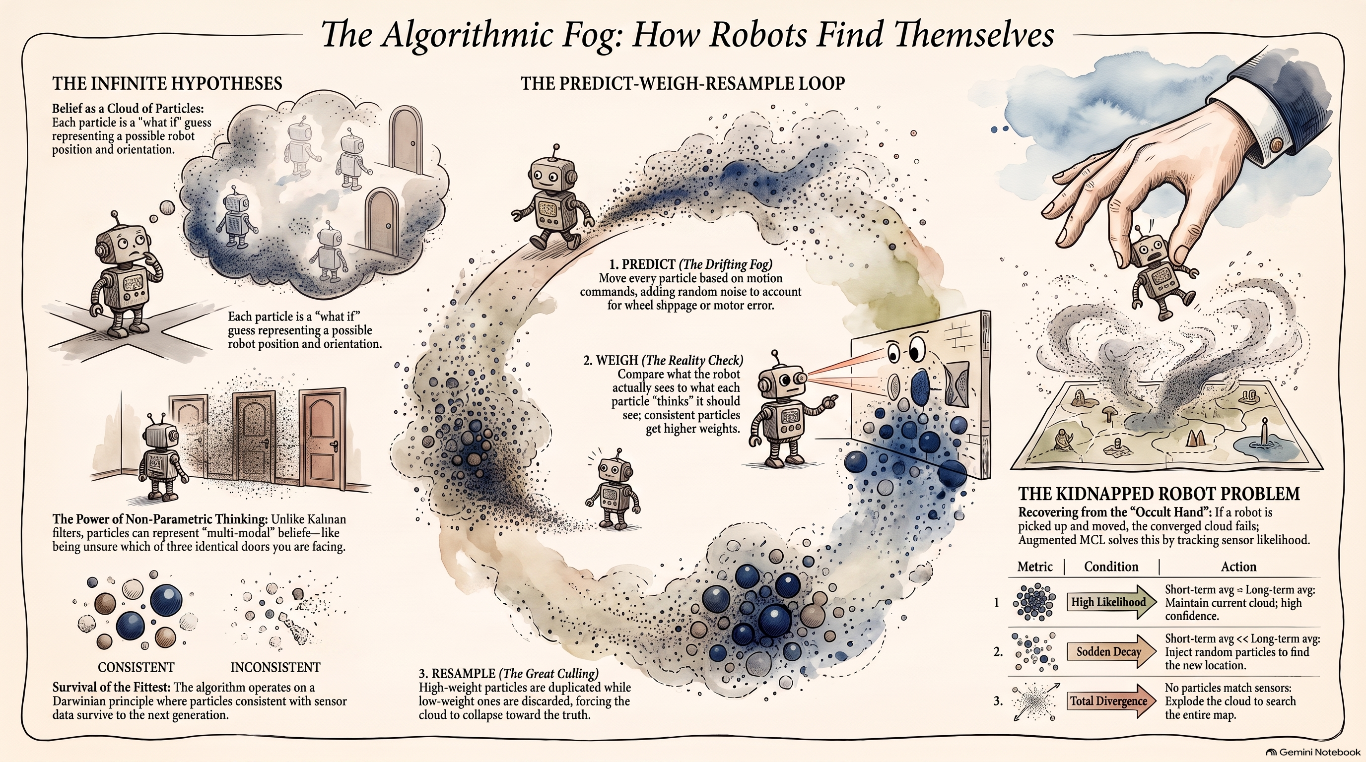
-
🤔 ❓do you have a particle filter in your brain?
-
you are in a room and you lose the power and lights. how would you navigate?
-
you generate hypotheses, you start feeling, probing, feel the edge of the bed
-
generate hypotheses, get data and test these hypotheses
-
geometry of the environment becomes features that the particle filter will use
Back to NAVIGATION2
- Map topic generated by Map server
- also generates an occupancy grid topic
-
LIDARnode also created -
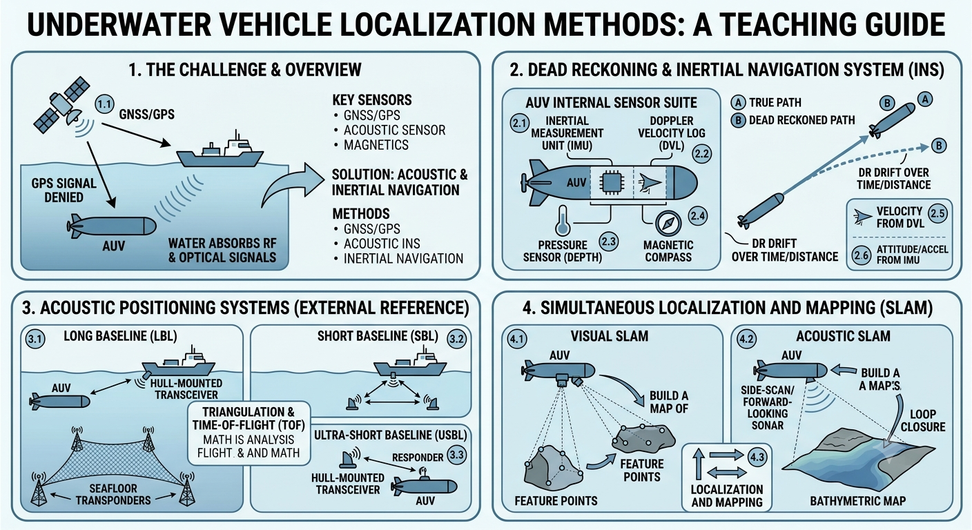
🤔 ❓what if there is a featureless environment (marine/ocean)?
-
clock (sun), compass, weather, underwater features, celestial navigation
-
underwater autonomous mapping, drill through ice, collect data on ecosystems
-
how do you solve this problem?
-
rely on IMU
-
sonic/acoustic signals localize underwater
- paper on SLAM underwater (see figure 7)
Visual SLAM
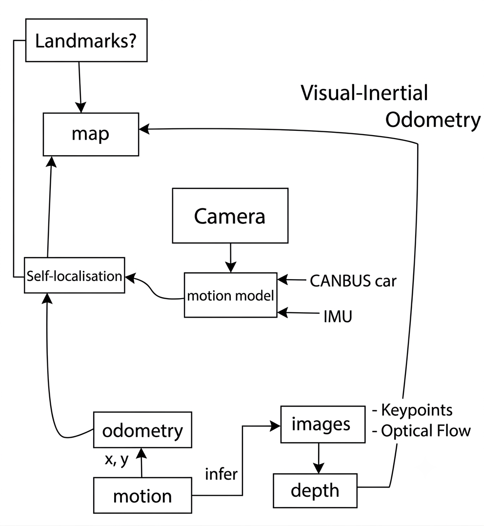
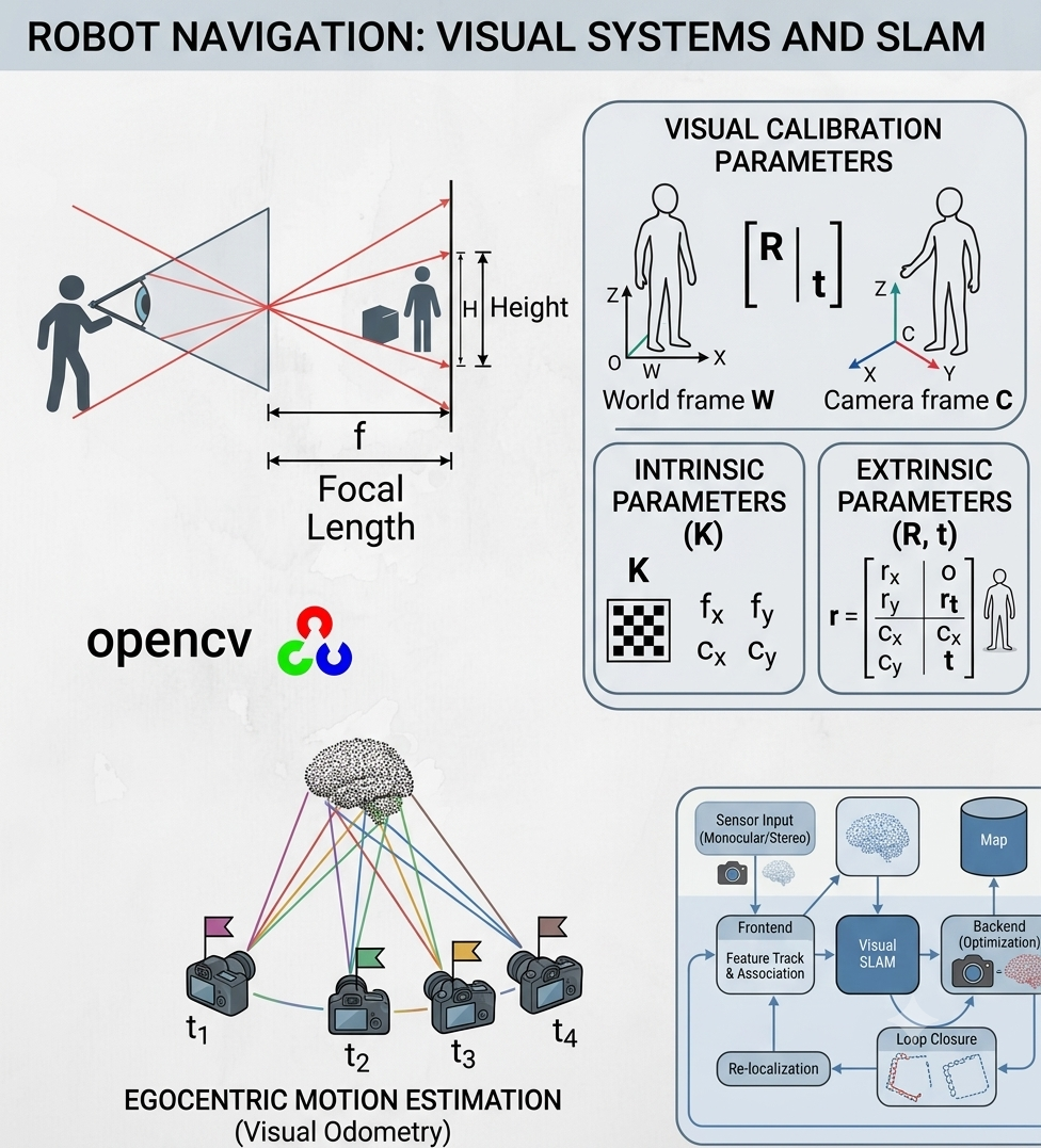
- visual odometry
-
AR codes
-
Detect features like corners
-
Look at same object from different frames and infer
-
motion of object (while tracking AR code)
-
similar to augmented reality where you are (say) visualizing a dinosaur from different directions as you move around the room
-
monocular SLAM(one camera system) -
with binocular system, you can use disparity between two images to get depth of objects
Differences between visual odometry and visual SLAM
Back to visual SLAM
-
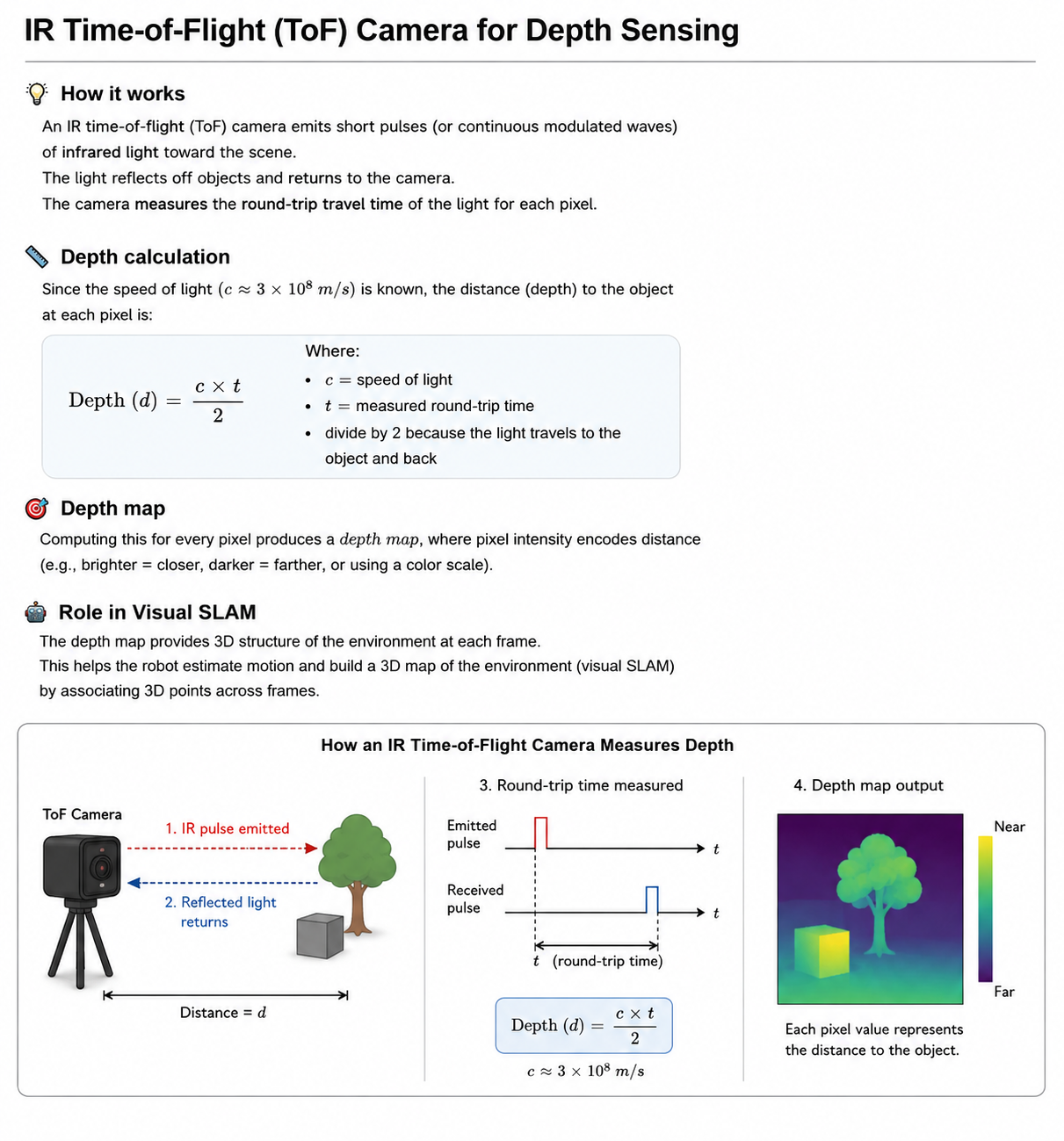
IR camera
-
An IR time-of-flight (ToF) camera emits infrared light and measures how long it takes for the light to travel to an object and back to the sensor. Since light travels at a known speed, the measured travel time gives the distance:
-
Depth = (speed of light × round-trip time) / 2 -
The camera therefore produces a depth map, where each pixel contains the distance to the corresponding point in the scene. In visual SLAM, this depth information helps the robot estimate 3D structure and its own position without relying solely on stereo correspondence or monocular scale estimation.
-
these are called RGBD cameras (D for depth)
-
IMU has accelerometer and gyroscope
-
by combining them you can have visual inertial SLAM or visual inertial odometry
-
distance between two cameras in binocular must be known
MonoSLAM
-
opencv
-
initialization step known target
-
smooth motion model
-
feature tracking
-
direct method use all information from frame to infer which direction camera is moving and infer
odometry
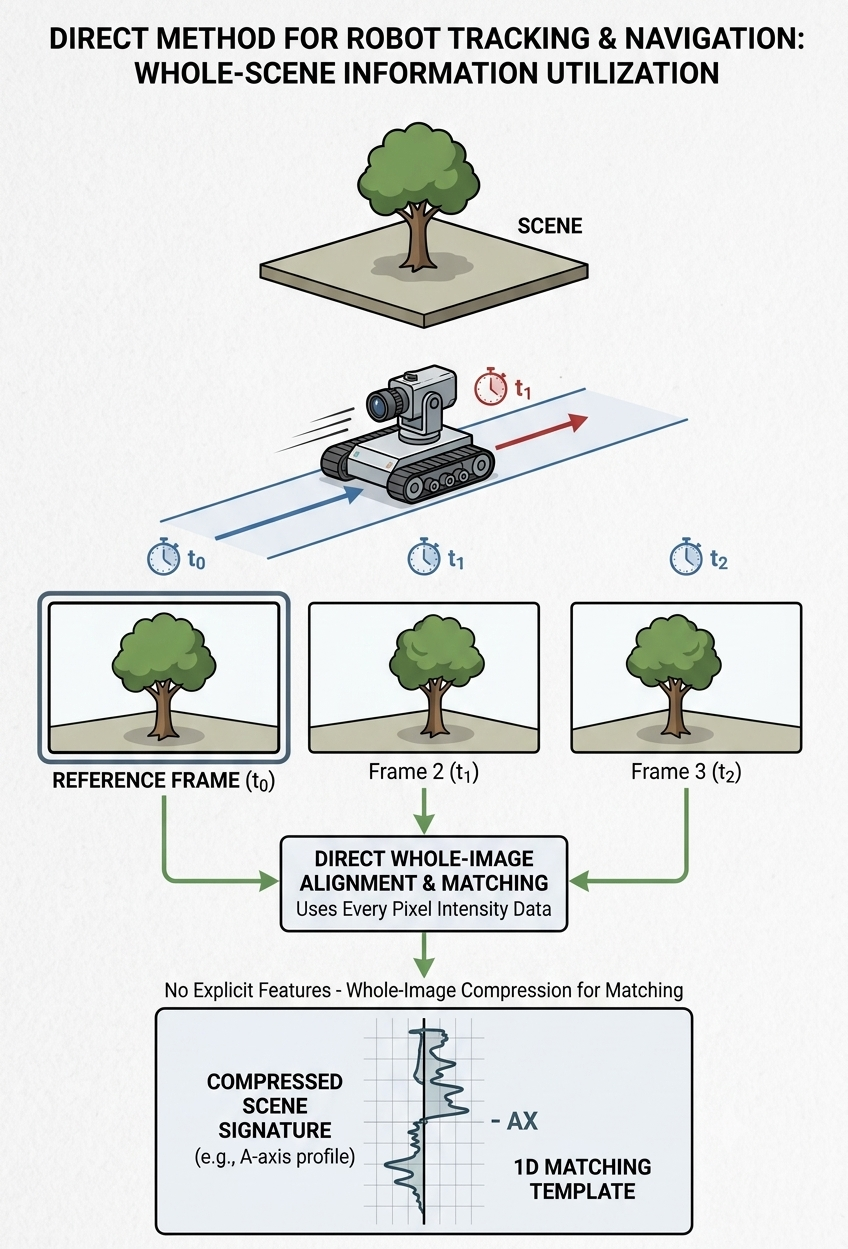
- feature based: use feature like corner
-
there are different kinds of SLAM that uses direct or indirect method
-
Recap: visual SLAM builds a map using visual features and self-localizes in the map
-
by moving the camera, we can detect the depth of objects
-
you can then project things into the environment (Pokemon)
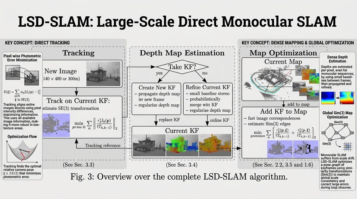
- parallel tracking and mapping (PTAM)
- tracking key frames
- then project virtual objects into that environment
-
if features removed, then system will get confused
- with two cameras infer depth (if distance between cameras known)
- visual odometry: direct vs. indirect
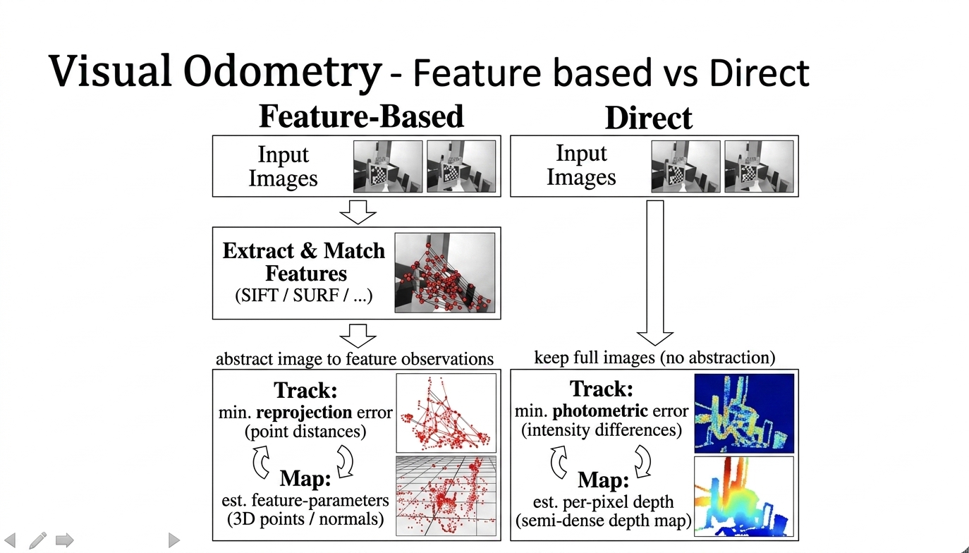
- monocular SLAM. need key frame
- 🤔 ❓what problems can occur if you use odometry to build a map?
-
use landmarks
-
you track a particular feature and you know that it is (0,0) origin
-
refine the estimate and correct drift
-
🤔 ❓what challenges can come up when you are building semi-autonomous robots doing navigation on Mars?
-
filter based and motion model (Kalman filter)
-
get better estimate of odometry
Real time appearance based mapping (RTAB-MAP)
-
STM short term memory
-
occupancy map in 3D
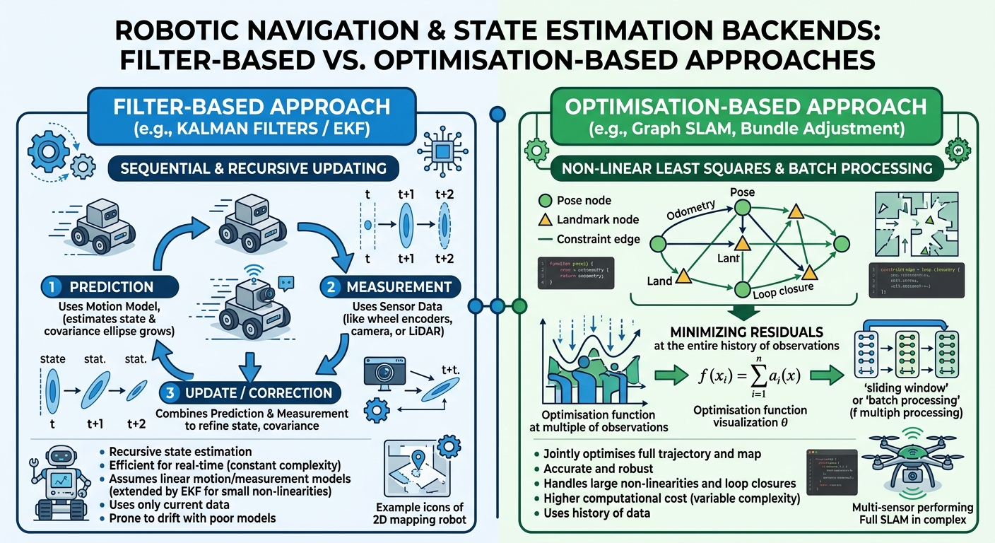
Backend
-
optimisation based approach
-
filter based approach (Kalman filters, extended Kalman filters)
-
filter based vs optimisation based (see figure below)
- lecture material on filters vs. optimisation here
Motion models
-
odometry sensors to estimate camera motion
-
constant velocity model: assumes that the camera moves at constant velocity
-
loop closure detection
-
backend and frontend and map
🤔 ❓Case studies
Discuss the following with your peers (class discussion)
- autonomous SLAM
- indoor
- city navigation
- mining